Saturday, May 11, 2013

A Day On The Ben


6:00am Awake and cosy in a borrowed bivvy bag, in the North Face car park.  Birds singing. Crisp cold air as I fold back the top of the bag.  Light the stove for coffee, eat an eccles cake, pack my bag and lock up the car. Off up the track by 7am.

8:00am Allt na Mhullain track. The Ben looming ahead, lots of snow and ice on the ridges and faces. Sun shining, blue sky and high clouds. Marching up just below a jog, sweating freely.

8:20am CIC Hut. Swap running top for dry Merino base layer. Lovely. Crampons & axe out, no other gear needed. Head off into Coire na Ciste.


8:45am Below Trident Buttress. Jubilee Climb is thin & incomplete, so off to Ledge Route. Traverse into No. 5 Gully & climb down to the first ledge.

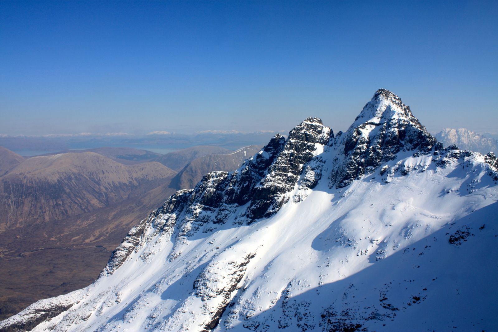
9:30am Admire the view from Ledge Route over to Tower Ridge. Perfect conditions. Maybe I should have done that instead? No big deal, lots of options ahead.


10:20am Top of Ledge Route. Another eccles cake and a flapjack. Beautiful views all round.

10:30am Down No. 4 gully. Stepped out, and too bumpy to glissade. Stomp down the steps to the foot of North Gully.

11:00am First pitch of ‘Wendigo’. Steep ice but perfect condition, solid and plastic and safe as houses. Using my old Vertiges, and getting first time placements every time. A joy to climb. The neve slope above continues the fun, pure white frozen snow which squeaks as the axes sink all the way in. Don’t fancy the rock pitch above, so traverse easily to the top of North Gully and finish up just above No. 4 Gully.


11:30am Back down No 4. Head over to No. 2 Gully.

12:00 Bit of a slog now. Steep snow up to the gully, stopping often to rest aching calves.

12:30pm No. 2 Buttress looks more interesting than the Gully – three good ice pitches, linked by clean stretches of neve, weaving between the rocks. Looking up, choosing a line, spotting places to rest. Yeah. That’ll go.


1:00pm First two ice pitches over, resting on the neve above. It’s a long way up, sensationally poised above the gully, and looking across to a pair climbing on the other side. The leader pulls off a huge plate of ice. Cue shouting. Lots of shouting.


Above the third ice pitch, more ice tucked away between the rocks. Resting, flexing my ankles to ease cramping calves, wiggling fingers to keep them warm. Really a long, long way down. The ice is even better now though. No hurry, rest and enjoy the position.  Savouring the climb, the views, the conditions, the pleasant ache of muscles working hard.

1:45pm Above the last rocks, steep neve to the plateau.  No cornice. Feeling the effort now, thighs and calves protesting, sweat running into my face, breathing hard. Easy to get sloppy with the axe swings and front-pointing.  Concentrate, make every one count. The gully yawns on one side, and the buttress falls away 200 clear metres below. Don’t stop.


1:55pm On the plateau, flat on my back. Gasping up into the blue sky. Walkers plod past, politely curious. Did you just climb up there?
Yes. It’s fine, really. Solid. 
No problem.

2:15pm Lunch at last, on the summit.  Another bright, clear, sunny day, in the best country in the world.


Winter On The Cuillin

British Summer Time started on Sunday morning, but the weather gods hadn’t got the memo. Looking over from the summits of Kintail, I could see the Cuillin with a top coat of white. So on Monday morning I was off down the road to the bridge and onwards to Skye.


My first goal was Bla Bheinn, so by lunchtime I was parking next to the path to Camasunary. I scoffed a couple of macaroni cheese pies from the Co-op on Kyleakin, (essential complex carbs, really) and then headed off to the bothy at Camasunary. After leaving my sleeping & eating gear there I headed up the south ridge of Bla Bheinn. The ground was bone dry, the grass brown and brittle. I found a decent path on the crest of the ridge, and made my way easily up to the snow line. The gullies on the west side presented stunning views of Sgurr nan Gillean and the whole Cuillin Ridge, snow-crested under Alpine blue skies. I had the hill to myself until the summit, and then saw only 4 other folk. Crossing to the northern (true) summit entailed a slightly awkward step, but other than that it was straightforward. I descended the same way, back to the bothy, arriving back as the sun dropped behind the Cuillin.


It was an international guest list at the bothy – French, German, Czech and Irish. An idyllic starlit evening followed, by the beach, where the French had collected a mountain of fresh moules. They steamed them on the bothy fire and shared them around, along with various beers and whisky.


I got up early the next day, and left the others snoring as I walked back to the car. From there I drove round to Sligachan, and set off into Fion Coire. Here it was another Alpine day – pristine frozen snow, deep blue sky and rocky summits. I plodded up the back wall of the coire, then walked round first to Sgurr a Bastier. Across the coire, Pinnacle Ridge looked fantastic, in perfect winter nick. I traversed around to Sgurr a Fion Coire, and climbed a short gully to its summit, then descended another entertainingly icy gully on the far side. From there, it was an easy plod up to Bruach na Frithe, which gave me a breathtaking view of the rest of the Cuillin, fully iced up from this aspect.


Throughout the day there’d been a haziness in the otherwise clear air, and the faint smell of smoke. Back in the car, I heard about the enormous wildfire just north of Fort William. Other smaller fires were visible on the island and mainland too. I found out later this is traditional, “Muir Burning”, by which farmers and landowners seek to improve the grassland. Traditional it may be, but not a good idea when they haven’t had rain for 6 weeks!

I drove to Carbost, hoping to get into the bunkhouse at the Old Inn, but they were full. The barman recommended instead The Croft Bunkhouse, a few miles down the road in Portnalong. An excellent choice as it turned out, well worth the extra couple of miles. It’s really comfortable and welcoming, with an excellent living room, kitchen and bunks. They also have a bothy and those wee wooden pods that are springing up all over the Highlands.

Up early next day, and off back to the Cuillin. I parked at Glen Brittle and walked up into Coire Ghreadaich. A fairly tedious scramble got me within sight of the west ridge, but thin icy snow made it quite difficult to reach. I climbed a snow gully only to find the rock at the top coated in ice, so had to reverse the whole thing. Another couple of false lines found me frustrated and still below the ridge. Fortunately I spotted a snow slope which then gave me an easy route to the summit of Sgurr a Mhadaidh (pronounced, for some reason known only to the natives, as “Sgurr a Vatay”)


A well-earned sarnie and flapjack there, as I surveyed the rest of the Cuillin. It wasn’t so sunny, but there was still no wind and the snow conditions were excellent. So I set off along the ridge with a spring in my step. I descended to An Dorus, then climbed a good snow slope to the first summit of Sgurr a Ghreadaich (“Hreetay”). It was a huge pleasure to be moving over good steep snow and rock; definitely another Alpine feel to the day. At the main summit I stopped for an eccles cake, but the wind had picked up, so I carried on south along the ridge. After the next summit, the ridge drops steeply before rising again to Sgurr a Banachdaich. The guidebook told me there was no easy way off until Banachdaich, and so I decided to turn around there and re-trace my steps to An Dorus. From there, it was a fun descent down snow slopes to the Coire, and a leisurely walk back to the car.

I spent the evening at The Old Inn first, where I bumped into a mate from Glenmore Lodge, now working for Mike Lates. After that, beer and whisky back at the bunkhouse, with the Czech lads, and an early night.


The next day was my last, as I wanted to head south to Ben Nevis and sample the excellent conditions there. So I was up at dawn, packed and drove back to Glen Brittle. I had a plan to do Sgurr a Banachdaich and then the Inn Pinn. The first leg of this, up into the coire and onto the ridge was fairly easy, and I was at the summit in good time. However there was persistent low cloud over Sgurr Dearg, and a frost on the rocks – not ideal conditions to solo the Inn Pinn! So I set off back down the ridge to Glen Brittle, which gave a few entertaining scrambly bits. Predictably, the sun came out and the cloud lifted, but I didn’t really mind. It had been an exceptional few days, the best I’ve ever seen on Skye, or anywhere else in Scotland for that matter!  Quite a week, and it wasn’t finished yet…


Thursday, April 11, 2013

Easter In Kintail


With admirable economy of expression, they call it “The Wee Bunkhouse”. Oddly sited in the car park of the Kintail Lodge Hotel, it’s about the size of a domestic garage, and probably once was one. However it was enough for 6 of us, while the rest of the LMC meet lounged in the sumptuous extravagance of the Trekkers’ Lodge.


Although the West Highlands had escaped the huge snowdrifts of the Peak and Lakes, it was still very much winter – frozen ground to sea level; the tops very white; and ice visible in the gullies above the road.  John & I stopped off in Glencoe on the way, for a quick snowy walk to find the “secret” ice crag of Eilde Canyon (successfully), which put us in a winter mood.

First target: The Saddle via the Forcan Ridge. Dave C, Cath, Dave B and I set off on Friday morning in bright but bracingly cold sunshine. The snow line was just below the start of the ridge, and it looked enticingly Alpine under blue skies. The ridge gives a good wintery scramble, in parts exposed but nowhere too technical.  It took longer than expected, but presented some stunning views along the way.


The summit gave us some good views, especially over to Skye, where the white tops of the Cuillin stood out in the sun. Ladhar Bheinn looked especially fine to the south too. We descended easy snow slopes to the bealach between The Saddle and Sgurrna Sgine, where we met a man who kept falling down holes.

It seemed a long slog up to Sgurr na Sgine, but probably wasn’t, we were just getting weary.  We found a couple of ptarmigan on the way, which brightened up the slog. More fine views rewarded us at the summit. Then came a short ridge walk, and steep fast descent to the road.

Back in our Wee Abode, Dave & Wayne had been scouting out winter crags, and found a couple of promising venues. Stuart arrived later, having had a good climb on The Ben with John on the way up.

Saturday morning was very cold and sunny, as Dave C and I got up early to do the Five Sisters (oo-er).  Due to a foolish navigation error (we were distracted by talking about folk who make foolish navigation errors), we gained the ridge just after the first summit. After a brief discussion, we doubled back to bag it anyway, just in case it was one of the Five (it wasn’t.) Then we had another fine, cold ridge walk, on mostly good frozen snow and with blue skies all round.  Most impressive were the dramatic views down the crags to the north. Where was everyone else though? We met only two people on the whole walk.


Dave and Wayne found a very wintery corrie on the South Glen Shiel Ridge, and had a great day climbing ice there, despite Wayne picking up a mysterious finger injury. Stuart took his bike over towards Applecross, to cycle the Bealach na Ba, one of the finest road routes in Britain.

The stunning weather continued on Sunday, as Dave C, Stuart, Cath and I set off for the South Glen Shiel Ridge. This meant a long walk in from the Cluanie Inn, but we made the first summit in good time & then had a superb winter ridge to negotiate. Tons of snow on top, and in the northern corries, where Dave and Wayne were having fun on good ice far below. Once again, bright sunshine & blue skies predominated.  The views all around were outstanding, and the snowy terrain always interesting. We even had to traverse the back of a huge cornice – another very Alpine feel to the day. We made our way over 4 Munros before heading back down to the second car, and a celebratory coffee at the Cluanie Inn.


Monday morning meant a long drive back for most of the others, but I was still on holiday and had been looking longingly across to the Cuillin for 3 days. And with a stable forecast for the rest of the week, there was only one direction I was going to go…

Monday, March 04, 2013

I'm Too Old For This...


Back to Rjukan! Back to the land of the ice and snow, of the midnight sun where the hot springs flow…

… Where was I? Oh yes, Norway.  This would be my 4th visit to that little industrial town in the heart of Telemark, not the most attractive of locations but boasting the highest concentration of easily accessible icefalls anywhere in Europe. Or indeed beyond, as we were surprised to meet a couple of climbers who had flown over the Pole from Washington State, claiming that was actually easier than driving around at home, looking for good ice.

Scouse and I were both well aware of our limitations – averaging one week ice climbing every 2 years can’t exactly be called experienced – so we had started modestly, by going to Vermork Bridge and mistakenly climbing a WI4. (It was supposed to be a WI3, but in my excitement I led us to the wrong icefall.) With both of us sporting new boots, and me trying to climb leashless for the first time, it was an eventful few hours, involving my very first fall on ice (no harm done) and Scouse pulling off some mighty moves to finish the route. We moved on to a much easier WI3 to get our nerve back, which apart from my bottoming out a screw in some thin ice (hugely annoying) passed without further mishap.

Day 2, we wanted a multipitch route, so went to Bolgen in our little rented Fiat 500. Short walk in, but another pair had just started the route so we had to wait. Bolgen is a 4-pitch WI3, quite wide so I thought we’d be able to avoid falling ice from the other pair. Why don’t I learn? After a long day, waiting on belays and dodging ice. we had to finish the abseil back down by headtorch. We counted it a successful day though.

From a mild start, the temperature had fallen rapidly. We went to the Lower Gorge the next day, but found the sudden cooling had made the ice very brittle and under thermal stress. Each axe placement dinner-plated and shattered, and more worryingly, large deeper cracks appeared through the ice. I’ve never encountered that before, so we climbed very cautiously, and I backed off after triggering a sequence of cracks that threatened to join up underneath my next moves. In the hostel later, a pair of Swedish ice climbers said they’d found similar conditions, and despite being much more experienced, had also never seen it happen before. So we felt our honour restored.

By mid-week, the daytime temperature was down to -12 C. We set off to Krokan, but found with the short easy walk in, we didn’t warm up and by the time we’d geared up we were frozen and suffering. After some debate, we decided we were too old for this shit, and we bravely sacked it off and went to climb in the sun at Rjukan Central. Here it was much nicer, in direct sun, blue skies and good views of Gaustatoppen, almost an Alpine feel to the day. We climbed a meandering line up the falls, given WI4 in the guidebook but a soft touch with good plastic ice and neve.


Friday arrived, and we felt we were now climbing well enough for our main objective, the stunning amphitheatre above Mael. This is a big day out, with 3 abseils to reach the bottom, and then a 4-pitch WI3 being the easiest way back out. This time we had the route to ourselves, just one other pair on the WI4 icefall next to us.

The ice was still very brittle, so it was hard going. By the end of the second pitch, we’d hacked our way up one side to belay in some trees. A shorter pitch got us to a wide ledge, with a steeper pitch above. I led up this next pitch to a final steepening, which Scouse then threw himself at. He had to stop after about 15 metres, as there was water running down the final ice wall. Puzzling to see this at consistently sub-zero temps. I tried an offshoot to the side, but by now the light was going and I was spent. Reluctantly I backed off, arms like jelly, and set about drilling an Abalakov.

One long abseil got us back to the big ledge, where we could walk off into the forest. I say walk, but once in the trees it was a case of wriggle, squirm and curse our way up.  There followed a couple of hours of thrashing through the woods, at night, with no map and only a vague idea of where the track was. Hilariously, we got within 20 metres of it at one point, only to decide we’d gone wrong and head back the way we came. What larks!

On the way back, we stopped at the pizza takeaway. Only £18 each, and well worth it. Honestly.

The next day, Scouse’s big toe, which had been on the end of several hundred kicks into hard ice, had gone purple. Nothing more to be done than go swimming, have a sauna and muck about in the rotating outdoor pool. And then doss in the TV lounge with a talkative Swede until it was time to drive back to Oslo, and home.


Friday, June 17, 2011

Cape Wrath Trail, Day 13 to 15

Day 13


Strathcailleach to Cape Wrath, & on to Kearvaig

After yesterday's navigation debacle, I had the map & compass out to plan my route in detail. Oscar and Mark gave me the grid reference for the point they'd crossed the MOD fence the day before. I took a bearing, estimated the distance at 3 km, and judged it would take about an hour over trackless but clear ground. So 56 minutes later, I was gratified to be striding up to exactly the point where they had covered the barbed wire with plastic bottles, to climb over. From there, I took another bearing, taking me over a small hill and meeting the track to Cape Wrath Lighthouse, about 4.5 km away. At the top of the hill, I could see the track but not the lighthouse. I had a surge of relief and exctiement; barring a very unlikely accident, I knew I was going to make it!

I reached the track just over an hour later, and then strode out along it to the lighthouse. This is hidden around the other side of a small hill, so you don't see it until only a couple of hundred metres away.

I noticed there was a small cafe there, but I'd planned to make a brew myself. I sat in front of the wall, out of the wind, looking out over the Atlantic, next stop Newfoundland (I couldn't see it.) I'd been saving a small cake (chocolate brownie) for the occasion, and had it with a cup of tea, watching a skein of geese fly past. As I was packing up, a minibus arrived with a group of tourists. After 2 weeks of near-solitude, I was perhaps a bit too eager to talk to them. However they all seemed impressed when I told them I'd walked there! I caught up with their driver in the cafe, and arranged to be picked up from Kearvaig Bothy at 1pm the next day (thus saving me a long walk to the Kyle of Durness).

Strolling down the track towards Kearvaig, I had a sense of quiet achievement. I'd made it to the Cape within 2 weeks, mostly under my own steam (hitched rides aside!) I'd been under a mild but constant pressure to keep walking, and get just that little bit further each day. Now that pressure was lifted, and I now I could look forward to a relaxing night in a good bothy.

Kearvaig Bay came into view, and didn't disappoint. A perfect golden beach, enclosed by high cliffs, with a turquoise sea breaking over the rocks, and the white-walled bothy set on a green lawn. No-one else was there, but there was a box of firewood and a supply of bottled water, left by the MOD who use it regularly. I had a brew, then went out exploring. It was a windy and hazy day, with a slight haar coming in off the sea. When I got back to the bothy, three fishermen had arrived, with a very welcome bag of coal; and then later more walkers arrived. The weather improved, and we all enjoyed a clear if chilly evening, watching the lingering rays of the sun slowly fade, and the stars come out overhead. In the gloaming, we also spotted a fox trotting along the beach, no doubt in search of seabird nests. An idyllic end to a fantastic walk!

Distance: 17.5 Km
Time: 4.5 hrs


Day 14

Kearvaig back to Ullapool

I felt I deserved a lie in, but even so I was up reasonably early. It was a sunny and breezy day, and the bay looked even more beautiful in the clear morning air. I took a walk up along the clifftops, taking pictures of the nesting birds on the cliffs. At one point I disturbed the fox, which ran off from behind a rock, where it had presumably been dozing and dreaming of fresh eggs. The others had all gone off for the day, so fittingly enough I had a last brew and lunch on my own, then walked up the track to wait for the minibus.

I was picked up shortly after 1pm, and was soon at the Kyle of Durness, another beautiful spot. Seals basked along golden sandbars, and a variety of sea and land-birds wheeled around us. The "ferry" arrived, actually just a man in an open boat with an outboard motor. As it was still windy, we had a bit of a soaking on the way over, although it was still sunny.


At Durness, I first thought I might have made a mistake. I was relying on hitching a lift south to Ullapool, but it was a suspiciously quiet road! I just had to be patient though, and after a while a retired couple picked me up. They were on a scenic drive, and decided they might as well go to Ullapool too, so they very kindly took me all the way to the campsite. I celebrated that evening at the Seaforth Hotel, in their seafood bar, with a huge plate of their award winning fish and chips. 

Day 15

Ullapool to Glenfinnan

Another early start, and breakfast at the Tea Store; then I started hitching back to Glenfinnan. The day went very well, with my first lift taking me to the outskirts of Inverness; the second down Loch Ness as far as Drumdrochit; and the third all the way back to my car at Glenfinnan.

I arrived at the car two weeks and half an hour after leaving. A quite surreal feeling! I changed into some clean "ordinary" clothes, and set off back down to England; with a strange mixture of feelings. Relief at finishing and everything going to plan; proud that I'd made it without any major mishaps; delighted with such fine weather; anticipation of sleeping in my own bed that night; but sad to be leaving that beautiful country.

I promised myself, I'd be back soon!

Monday, June 13, 2011

Cape Wrath Trail, Day 10 to 12

Day 10

Elphin to Quinaq

Here my route deviates from the usual Cape Wrath one. Rather than head east to Knockdamph, I wanted to go north through Inverpolly, past Suilven. This meant a long hike up the road out of Ullapool, which I shamelessly avoided by hitching. I quickly got a lift up to Elphin, and was off along the track by 8:30am. I reckon this cut a day of walking from the overall trail, but I'm not a purist or claiming any records. Anyway it's my holiday, so there.

Another sunny and breezy day, with Suilven and Canisp rising dramatically ahead of me. Unfortunately I lost the path after a couple of miles, and had to slog over grass and bog for a mile or so. Falling over at one point didn't help my mood. But then back on a good landrover track, which led me along and below Suilven. It's a very impressive mountain, with its steep sides, two main tops and undulating ridge. I ate lunch underneath it, and shortly afterwards met some guys just down from the summit, which was extremely windy. I also dropped into Suilag Bothy, and was tempted to stop there. However it wasn't even 2pm yet, so I left it for another trip.

The rest day in Ullapool hadn't done me as much good as I expected. I think I'd got out of the rhythm a bit, and my heels were complaining again. A stretch of road walking, with no lifts available this time, didn't help. I took the path up to Gleann Leireag which took me towards Quinaq, another very beautiful mountian. I found a camping spot beneath the crags on the North west of Quinaq, and it was a very impressive spot in the evening sun. The wind dropped too, and so after quite a hard day, I enjoyed an idyllic evening, sitting in the tent brewing tea & eating eccles cakes.

Distance: 26 Km
Time: 10.5 hrs

Day 11

Quinaq to Loch Stack

Another fine morning, although chilly and heavy dew on the tent & grass around me. The sun soon burned off the light cloud, and it was a easy walk out to the minor road which leads to Kylesku. I didn't mind walking along the road in the cool morning sun, there were good views of the coast, each bend of the road revealing another little idyllic bay. After about an hour though, a car stopped and offered me a lift. Rude to refuse, I thought, and so I got a lift to Unapool, about 1 1/2 miles from Kylesku. There I got a cheese & ham toastie and pot of tea from the very twee 'Teashop, Doll and Toy Museum'. This offers a great view of the geologically important Moine Thrust and Glen Coul Thrust, which can be clearly seen in the slanted rock strata above the lochs.

From there I walked up the road and then took the track towards Loch Stack. It was still sunny and breezy, and the extended dry spell was giving me some problems. Normally I'd refill my water bottle from streams along the way, but with water levels so low many were stagnant and very peaty looking. So I was often quite thirsty along the way.

I had a superb view of Arkle and Loch Stack as I descended, once again more reminiscent of the Alps than Scotland. I met the only other walker of the day, an older lady who'd come over from Kylesku that morning & was on the way back again. Once down through the forest, I walked along the road, this time no-one gave me a lift and by the time I reached Loch Stack Lodge I was hot, tired and thirsty. I continued on a stalkers' path until I found a spot by a lochan, and camped there. It had been a long day and I was glad to just flake out early.

Distance: 30 Km
Time: 9.5 hrs

Day 12

Loch Stack to Sandwood Bay (Strathcailleach)

Another cool and breezy start, but sunny after an hour or so. I walked out to Rhiconich Hotel, and the sun not yet being over the yardarm, enjoyed a pint of orange & lemonade there. Then walking and hitching up the road to Kinlochbervie, where I bought some more food. From there I got a lift all the way to the Sandwood Bay track.

By now I was feeling fit, my aches and pains had all gone, the sun was out and I was within a day's walk of the Cape. I yomped over to Sandwood Bay in just over an hour, and took off my boots for a walk and paddle along the length of the beach.

Sandwood is said to be the best beach in Britain, and on a sunny afternoon I certainly wouldn't disagree. A huge perfect stretch of golden sand, with the turquoise sea rolling in, it could be mistaken for a tropical idyll. Until you try paddling, when you find the water removes all feeling from your feet in about 30 seconds. I had a very relaxing couple of hours there, comfy in the knowledge that my next stop, Strathcailleach Bothy, was only a couple of kilometres away.

Rabbie Burns said, of the best laid plans, "gan aft agly". I reckon I went aft agly as soon as I left Sandwood Bay. Looking at the map now, I have no idea how I managed to miss the bothy, but I ended up hacking over heather and bog for far longer than I should have done. I know very well that when you're lost, you go back to the last place you knew where you were. So I've no idea why I kept hacking on for another 3 km! By the time I stopped, mentally kicked my arse and started to retrace my steps, the sky had clouded over and bands of drizzle were sweeping in from the sea.

I finally found the bothy an hour later, and was glad to see I had company. The peat fire was lit and while peat doesn't exactly lend itself to roaring fires, it was putting out a very welcoming glow. Two Dutch fellas - Oscar and Mark - were in, they had just finished the Cape Wrath Trail and were retracing their steps back to Blairmore, to be picked up by their wives. They gave me some useful info and encouragement for the final day, and enthused over the Kearvaig Bothy, where I'd be staying after making it to the Cape..

Distance: 21 Km (should have been only 16 though!)

Time: Too long.